
The GTA V 5 map is a huge open world built around the fictional state of San Andreas, with the city of Los Santos and the rural expanses of Blaine County forming its most recognizable areas. From crowded downtown streets and luxury neighborhoods to deserts, mountains, beaches, forests, and military facilities, the map was designed to make every region feel distinctly different.
Understanding the GTA V 5 map makes Story Mode and GTA Online easier to navigate, especially when missions send you between opposite ends of San Andreas. Learning where Los Santos, Sandy Shores, Paleto Bay, Mount Chiliad, Fort Zancudo, and the major highways are located can save considerable travel time and make exploration much more efficient.
This GTA V 5 map guide breaks down the full map, its main regions, important cities and neighborhoods, major landmarks, rural areas, highways, secrets, and useful locations. It also explains how Story Mode and GTA Online use the world differently and how interactive maps can help when searching for collectibles or specific points of interest.
GTA 5 Map Overview
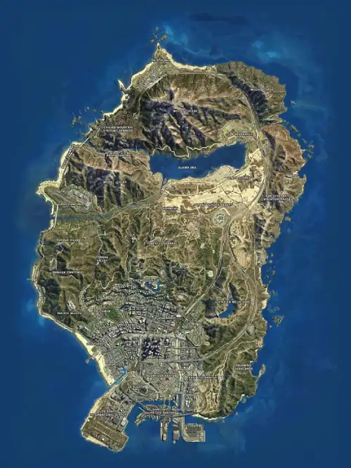
The GTA 5 map is heavily inspired by Southern California, with Los Santos serving as Rockstar’s fictional interpretation of Los Angeles and the surrounding countryside representing deserts, mountains, forests, agricultural areas, and small communities.
At the broadest level, players can think about the world in terms of the dense urban south and the much more open rural north. Rockstar’s own GTA Online documentation describes Freemode as the open world of Los Santos and Blaine County, where players can find properties, businesses, mission contacts, and social locations.
Here’s a quick overview of the major areas:
| Region | Environment | Important Locations |
| Los Santos | Urban | Downtown, Vinewood, Rockford Hills, Vespucci |
| South Los Santos | Urban/industrial | Davis, Strawberry, La Mesa |
| West Los Santos | Coastal/upscale | Del Perro, Vespucci, Pacific Bluffs |
| Blaine County | Rural | Sandy Shores, Grapeseed, Paleto Bay |
| Grand Senora Desert | Desert | Sandy Shores, Harmony, Route 68 |
| Alamo Sea | Inland water | Sandy Shores, Grapeseed |
| Mount Chiliad | Mountain | Cable car, wilderness, summit |
| West Blaine County | Coastal/military | Fort Zancudo, North Chumash |
These regions are connected by freeways, highways, mountain roads, trails, and smaller streets, allowing players to move between dramatically different environments without a loading screen.
How Is the GTA 5 Full Map Divided?
The GTA 5 full map is more complex than simply “Los Santos in the south and desert in the north,” but that distinction provides an excellent starting point.
Los Santos dominates the southern urban portion. This is where you’ll find Downtown skyscrapers, residential neighborhoods, beaches, industrial districts, Los Santos International Airport, and many of the locations associated with Michael and Franklin.
Travel north and the environment gradually becomes more rural.
Blaine County contains Sandy Shores, Grapeseed, Paleto Bay, the Alamo Sea, large portions of the Grand Senora Desert, wilderness areas, mountains, and Fort Zancudo. The region’s geographic diversity includes desert, forest, mountains, and small settlements.
Rather than viewing Mount Chiliad as a third major division alongside Los Santos and Blaine County, it is more useful to understand it as one of the major geographic landmarks within the northern part of the world.
Los Santos: The Urban Heart of GTA V
Los Santos is the most densely developed section of the map and the location where many Story Mode and GTA Online activities take place.
Rockstar built the city around recognizable Los Angeles influences while exaggerating them through GTA’s satirical style. Different neighborhoods represent dramatically different social and economic environments.
The city includes wealthy hillside communities, commercial skyscrapers, tourist districts, beaches, industrial zones, gang territories, and suburban neighborhoods.
Its road network is correspondingly dense.
This makes navigation very different from Blaine County. In the countryside, you can often identify your position from mountains, highways, or the Alamo Sea. Inside Los Santos, understanding major streets, freeway interchanges, and recognizable buildings becomes much more important.
Fortunately, several landmarks make orientation easier once you become familiar with the city.
Downtown Los Santos
Downtown Los Santos is one of the easiest regions to recognize because of its skyline.
The towering buildings around Pillbox Hill form the city’s central business district, with Maze Bank Tower serving as one of the most recognizable structures in the game.
Downtown is surrounded by neighborhoods and districts that connect it to the rest of Los Santos. Its central location means you’ll frequently pass through the area when traveling between the western, eastern, and southern portions of the city.
The dense road layout can initially be confusing, especially when GPS routes send you onto elevated freeways.
Instead of focusing exclusively on individual street names, learn the city’s major freeway routes and use the skyline to maintain your sense of direction.
Once those patterns become familiar, Downtown becomes an excellent reference point for navigating the entire southern map.
Vinewood and Vinewood Hills
Vinewood is GTA’s unmistakable parody of Hollywood.
The Vinewood Sign overlooking Los Santos is one of the game’s most famous landmarks and can be seen from many parts of the city. Below the hills, Vinewood Boulevard provides the game’s interpretation of Hollywood’s tourist-heavy streets.
Vinewood Hills offers a completely different environment.
Winding roads climb through wealthy residential areas above the city, providing excellent views but sometimes making GPS navigation slower than the straight-line distance suggests.
Franklin eventually lives in this part of Los Santos, while several Story Mode missions and GTA Online properties also bring players into the hills.
The area is useful for learning one important lesson about the GTA 5 map: distance alone doesn’t determine travel time. Terrain and road layout matter significantly.
Rockford Hills and West Los Santos
Rockford Hills draws heavily from Beverly Hills, making it one of the most affluent-looking areas in Los Santos.
Michael’s home is located here, placing the neighborhood at the center of numerous Story Mode sequences.
Moving west takes you toward neighborhoods and coastal regions inspired by some of Los Angeles’ most famous areas. Del Perro, Vespucci, Morningwood, Pacific Bluffs, and nearby districts create a mixture of commercial streets, beaches, expensive properties, and tourist attractions.
This side of the city also provides access to the Great Ocean Highway.
That road becomes especially important when traveling north because it follows the western coastline toward Chumash, Fort Zancudo, and eventually Paleto Bay.
For players who enjoy scenic driving, it is one of the most memorable routes on the entire map.
Vespucci Beach and Del Perro
Vespucci Beach and Del Perro form one of GTA V’s most recognizable coastal areas.
Vespucci takes inspiration from Venice Beach, while Del Perro incorporates elements associated with Santa Monica. The beach, canals, beachfront businesses, and Del Perro Pier create a very different environment from Downtown.
The pier is particularly easy to identify thanks to its amusement attractions and position extending into the Pacific.
This part of the GTA 5 map locations network is useful as a western reference point. If you’re near the beach, Downtown lies inland to the east, while the main coastal highway eventually takes you north.
Vespucci also appears frequently during general exploration, activities, missions, and GTA Online sessions.
South Los Santos
South Los Santos provides another dramatic contrast with the wealthy neighborhoods to the west and north.
Areas such as Strawberry, Davis, Chamberlain Hills, and Rancho are strongly connected with Franklin’s early Story Mode progression and several of the game’s gang-related narratives.
Franklin begins the story living in Strawberry before eventually moving to Vinewood Hills.
Nearby industrial and commercial districts also create important connections toward the Port of Los Santos and eastern portions of the city.
Learning South Los Santos is particularly useful because its dense road network can make short journeys surprisingly confusing when you’re unfamiliar with the area.
Use major freeways and the Downtown skyline as orientation tools rather than trying to memorize every neighborhood street immediately.
Los Santos International Airport
Los Santos International Airport, usually called LSIA, occupies a large portion of the southwestern edge of the city.
Its runways make it immediately recognizable from the air, while the surrounding road network includes ramps, terminals, parking areas, and highway connections.
LSIA becomes especially important when players begin using aircraft regularly.
In GTA Online, airports and airfields can also become useful reference points when planning longer journeys around the map.
The airport’s position provides another simple navigation anchor:
LSIA = southwestern Los Santos.
If you can identify LSIA, Downtown, the Vinewood Sign, and the coastline, you can usually determine your general position in Los Santos very quickly.
Blaine County: GTA V’s Rural Region
Travel north from Los Santos and the urban environment eventually gives way to Blaine County.
This is where GTA V’s world begins to feel much more open.
Blaine County includes major locations such as Sandy Shores, Grapeseed, Paleto Bay, Mount Chiliad, the Alamo Sea, Grand Senora Desert, and Fort Zancudo.
Trevor’s presence makes the region particularly important during Story Mode. His trailer in Sandy Shores places one of the three protagonists far away from Michael and Franklin’s Los Santos environment.
The geographic contrast is deliberate.
Instead of skyscrapers and tightly packed streets, you’ll encounter dirt roads, desert terrain, farms, mountains, forests, small towns, airfields, and long stretches of highway.
Sandy Shores
Sandy Shores is one of Blaine County’s most recognizable settlements and Trevor Philips’ home territory.
The town sits beside the Alamo Sea and is surrounded by the dry environment of the Grand Senora Desert. Its trailers, abandoned-looking buildings, dusty roads, and small businesses make it visually distinct from Los Santos.
Nearby you’ll find the Sandy Shores Airfield, another important Story Mode location.
Sandy Shores is also strategically positioned.
The Alamo Sea lies immediately nearby, Grapeseed sits farther north and east, while highways and desert roads connect the town toward Los Santos and western Blaine County.
If you’re learning the northern map, Sandy Shores is one of the best reference points to memorize first.
Grand Senora Desert
The Grand Senora Desert occupies a large area around central San Andreas.
It includes the dry terrain surrounding Sandy Shores and stretches across an environment filled with highways, dirt roads, industrial locations, and open land. The desert is bordered by major geographic features including the Alamo Sea to the north and mountain ranges to the east and west.
Route 68 is one of the important roads associated with this part of the map.
The region is excellent for off-road driving because you aren’t limited to paved roads. Dirt bikes, off-road vehicles, and aircraft make crossing the desert considerably faster.
Its open terrain also makes navigation relatively easy.
Unlike Los Santos, where buildings can block your view, the desert allows major mountains and the Alamo Sea to act as natural landmarks.
Alamo Sea
The Alamo Sea is the large inland body of water dominating central-northern San Andreas.
It is inspired by California’s Salton Sea and is surrounded by desert terrain and smaller communities.
Sandy Shores occupies the southern side of the lake, while Grapeseed lies to the northeast.
Because the Alamo Sea is visible from many surrounding roads and elevated locations, it is one of the best natural navigation references in Blaine County.
If you see a huge inland lake surrounded by desert, you immediately know approximately where you are.
The Alamo Sea is also surrounded by locations used for missions, activities, collectibles, and exploration, making it more than simply background scenery.
Grapeseed
Grapeseed lies northeast of the Alamo Sea and offers a rural agricultural environment.
Farms, open fields, dirt roads, and McKenzie Field distinguish it from the desert settlements around Sandy Shores. McKenzie Field itself is an important airfield associated with Trevor’s activities.
Grapeseed is useful as a geographic transition point.
Travel north and you’ll approach Mount Chiliad and the northern coast. Travel southwest and you’ll return toward Sandy Shores and the Grand Senora Desert.
The relatively flat agricultural terrain also makes off-road navigation straightforward.
For players exploring every GTA 5 map location, Grapeseed contains collectibles and mission-related points that are easy to overlook when following only the main highways.
Paleto Bay and Paleto Forest
Paleto Bay is the major town at the northern end of the map.
Its remote location makes journeys there feel substantial, particularly when driving from central Los Santos. The town is surrounded by forest, coastline, and Mount Chiliad’s enormous terrain.
Paleto Forest sits nearby and creates one of the most heavily wooded environments in GTA V.
The combination of small-town streets and surrounding wilderness gives this region a completely different atmosphere from both Los Santos and Sandy Shores.
Paleto Bay also becomes important during Story Mode, particularly around the game’s heist progression.
If you’re traveling there from Los Santos, the Great Ocean Highway provides a scenic western route, while other roads can take you through the interior of Blaine County.
Mount Chiliad
Mount Chiliad is the dominant natural landmark of northern San Andreas and the highest peak on the map.
Its enormous size makes it visible from many areas, which means it functions as a natural compass while exploring Blaine County.
Players can reach the summit through trails, vehicles, aircraft, or the cable car system. The mountain is popular for biking, hiking, parachuting, and off-road exploration.
Mount Chiliad is also associated with one of GTA V’s most famous mysteries.
The mural at the cable car station and related UFO imagery sparked years of community theories and exploration.
Even without the mystery, the summit is worth visiting simply for the panoramic view of the GTA 5 full map.
Fort Zancudo
Fort Zancudo is GTA V’s heavily restricted military installation in western Blaine County.
It sits near Lago Zancudo and Mount Josiah, close to the western coastline and Great Ocean Highway.
The base is immediately recognizable because of its enormous runway and military infrastructure.
In Story Mode, entering the installation without authorization results in a high wanted level, making casual exploration considerably more dangerous than visiting most locations.
The base contains military vehicles and aircraft, which naturally makes it attractive to adventurous players.
In GTA Online, access can work differently depending on owned properties and progression, but Fort Zancudo remains one of the map’s most recognizable restricted locations.
Important GTA 5 Map Locations to Remember
You don’t need to memorize every neighborhood to navigate efficiently.
Start with a small number of major landmarks:
- Downtown Los Santos: central urban reference;
- Vinewood Sign: northern city hills;
- LSIA: southwest;
- Vespucci/Del Perro: western coastline;
- Sandy Shores: central desert;
- Alamo Sea: central-northern landmark;
- Fort Zancudo: western Blaine County;
- Paleto Bay: far north;
- Mount Chiliad: northern mountain landmark.
Once you know these points, smaller locations become easier to place mentally.
This approach is much more practical than attempting to memorize dozens of neighborhood names immediately.
Over time, missions naturally teach you how these regions connect.
GTA 5 Interactive Map: Why Use One?
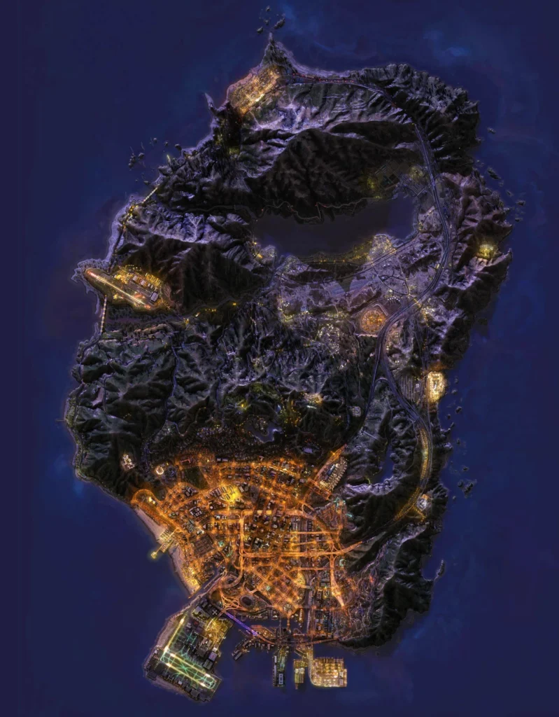
A GTA 5 interactive map becomes useful when the standard in-game map doesn’t provide enough detail for a specific objective.
Interactive maps can categorize points of interest and allow players to filter what they want to find.
Depending on the map being used, categories can include:
collectibles, missions, properties, weapons, shops, Easter eggs, stunt jumps, spaceship parts, letter scraps, peyote plants, and other secrets.
This is especially helpful for completionists.
Instead of searching an enormous open world for the final missing collectible, you can systematically check locations and keep track of areas you’ve already visited.
However, interactive maps are supplemental tools. For ordinary Story Mode and GTA Online navigation, the built-in map and waypoint system usually provide everything you need.
How to Navigate the GTA 5 Map Faster
The waypoint system is the easiest way to navigate San Andreas.
Open the map, select your destination, and create a waypoint. The GPS then generates a road route toward that location.
Rockstar specifically recommends using the map in GTA Online’s Pause Menu to browse available locations and set waypoints.
But GPS isn’t always the fastest possible route.
Off-road vehicles can cut across rural terrain, while aircraft dramatically reduce travel time between distant areas. Helicopters are particularly useful because they can land in smaller spaces than planes.
Learning the freeway network also helps.
When moving around Los Santos, major highways often provide faster travel than navigating surface streets, even when the GPS route appears slightly longer.
GTA Online Map vs. GTA V Story Mode
The core GTA Online map uses the same fundamental Los Santos and Blaine County geography players explore in GTA V Story Mode.
Rockstar describes GTA Online Freemode as the open world of Los Santos and Blaine County, filled with businesses, properties, mission givers, and other activities.
The major difference is how that world is used.
Story Mode fills locations with missions and activities connected to Michael, Franklin, and Trevor. GTA Online layers multiplayer businesses, properties, mission markers, social spaces, events, and other online content onto the world.
This can make the Online map appear much busier.
As your GTA Online character progresses and gains access to more content, the number of icons and available activities can become substantial.
Fortunately, map filters help control what is displayed.
Is Cayo Perico Part of the Main GTA Online Map?
Cayo Perico is associated with GTA Online but should not be confused with a normal extension of Los Santos or Blaine County.
It is a separate island used primarily for the Cayo Perico Heist and related content.
The island has its own important infiltration and escape locations, including the Airstrip, Main Dock, North Dock, and El Rubio’s Compound.
However, you cannot simply drive north from Paleto Bay and eventually reach Cayo Perico.
That distinction is useful when players refer broadly to the “GTA Online map.” The main free-roam world remains centered around Los Santos and Blaine County, while certain content takes players to separate locations.
Secrets and Collectibles Across the GTA 5 Map
One reason the map remains interesting after completing the main story is the sheer number of optional discoveries scattered across San Andreas.
Collectibles and secrets encourage players to leave highways and explore alleys, mountains, underwater areas, rooftops, farms, industrial sites, and remote wilderness.
Spaceship Parts are a classic example.
They are scattered throughout Los Santos and Blaine County, including areas around Grapeseed, Mount Chiliad, Sandy Shores, and Paleto Bay.
Letter Scraps provide another map-spanning search.
Stunt Jumps, hidden vehicles, Easter eggs, random events, and underwater discoveries provide additional reasons to explore.
This is where an interactive map becomes particularly useful: it turns an enormous scavenger hunt into a structured completion checklist.
How Big Is the GTA 5 Map?
You’ll find many different measurements for the size of GTA V’s map online, but these numbers should be treated carefully.
The result depends heavily on what is being measured. Some estimates count only accessible land, while others include water or use different methods to define the playable boundary.
Rockstar does not provide a simple official square-mile figure that resolves every comparison.
For players, the more meaningful characteristic is geographic diversity.
Driving from LSIA through Downtown, across the desert, around the Alamo Sea, and into Paleto Bay feels like crossing several distinct environments rather than one repeated landscape.
Terrain also changes perceived scale. Mountain roads and winding coastal highways can make two geographically close locations take significantly longer to travel between than expected.
Best Ways to Explore the Full Map
Driving is still one of the best ways to understand San Andreas.
Following highways teaches you how the major regions connect, while leaving the roads reveals an enormous amount of detail that is easy to miss during missions.
Motorcycles are excellent for mountain trails and narrow routes. Off-road vehicles make the Grand Senora Desert and wilderness easier to explore.
Aircraft provide a completely different perspective.
Flying above the GTA 5 full map quickly reveals its overall design: dense Los Santos in the south, the Alamo Sea near the center, mountains and wilderness toward the north, and the Pacific coastline wrapping around the island.
For a first exploration run, try traveling from LSIA to Paleto Bay without fast shortcuts. It provides an excellent tour of how dramatically the environment changes.
GTA Online Navigation and Network Performance
Navigating the map itself doesn’t depend on network optimization, but GTA Online adds a multiplayer connection layer to the same open world.
Online sessions involve communication between your system and game infrastructure, and network conditions can influence the consistency of that experience.
Latency, jitter, packet loss, and inefficient routing are different network characteristics that can contribute to connection problems.
They should also be distinguished from graphical performance.
Low FPS, texture loading, or hardware limitations aren’t the same as network latency and require different troubleshooting approaches.
Understanding that distinction helps avoid trying to solve a graphics problem with a network tool, or a connection problem by lowering graphics settings.
Explore GTA Online With ExitLag
The GTA Online map offers an enormous environment filled with businesses, missions, properties, races, heists, and activities spread throughout Los Santos and Blaine County.
When network routing contributes to latency variation, jitter, packet loss, or connection instability, route optimization may help improve consistency.
ExitLag is designed to optimize network routes for supported online games by searching for more stable paths between the player and game infrastructure.
It won’t make your vehicle faster, reveal hidden collectibles, or shorten the physical distance between Los Santos and Paleto Bay.
However, when inefficient network routing is contributing to GTA Online connection problems, optimization can help provide a more consistent multiplayer experience.
FAQ
There is no single universally accepted measurement because estimates differ depending on whether water and other areas are included. Rockstar does not provide one simple official area figure covering every comparison.
The world is primarily organized around Los Santos and the surrounding Los Santos County in the south and rural Blaine County farther north, with deserts, mountains, forests, towns, and coastal areas.
Los Santos occupies the southern urban portion of the map. Downtown, Vinewood, Rockford Hills, Vespucci, South Los Santos, and LSIA are among its major areas.
The main geography of Los Santos and Blaine County is shared, but GTA Online adds multiplayer properties, businesses, activities, mission locations, and other online content.
Use the in-game map and waypoint system for normal navigation. A GTA 5 interactive map is particularly useful when searching for collectibles, secrets, or specific points of interest.
Master the GTA V 5 Map and Explore Every Corner of San Andreas
The GTA V 5 map becomes much easier to navigate once you understand its major geographic anchors. Los Santos dominates the urban south, while Blaine County introduces Sandy Shores, the Grand Senora Desert, Alamo Sea, Grapeseed, Paleto Bay, Fort Zancudo, and Mount Chiliad.
Start by memorizing the biggest landmarks rather than every individual street. Once Downtown, LSIA, Vinewood, Sandy Shores, Alamo Sea, Mount Chiliad, and Paleto Bay become familiar, the rest of San Andreas begins fitting naturally around them.
Got questions or want to connect with other players? Join the conversation at the ExitLag Forum!